

.jpg)

Charger images
Les formats d'image autorisés sont de type jpeg, png ou gif
La taille maximale du fichier doit être de 20MB


.jpg)
St Germans is in East Cornwall.
St Germans is a village sandwiched between the A38 Plymouth to Liskeard main road further to the North and the closer A374 Torpoint to Trerulefoot road to the South. The Norman church of St Germans, or more correctly called St Germans Priory, a religious site has been here since AD 926, gives the village it's name. The present Norman church is often said to be the finest in Cornwall and the impressive Norman Western doorway is said to be one of the finest in the UK. The Earl of Port Eliott owns most of the land to the North of the village, Port Eliott Estate once the site of the some would say infamous 'Elephant Fayre' between 1981 - 1986, still holds music events, for instance 2024 two events are due to take place one in July and one in August.
After parking head East into Old Quay Lane, this lane starts off fairly open but quickly becomes more enclosed by trees and shrubs, at the bottom is a gate with a stone style (a rarity in this part of Cornwall) that marks the start of the footpath to St Germans Quay. Continue on this rough in places footpath, that goes beneath the impressive St Germans viaduct to the quay. Return to your parking spot uphill on quiet roads through the village.
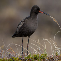
In the 1970's Fuligule milouinan, Spatule blanche and Chevalier arlequin were seen but we're very rare visitors, today of the three only Spatule blanche and Chevalier arlequin can regularly turn up mostly in Autumn/Winter, the latter twos regular spot is further down river at Wacker Quay (see separate entry). For a village tucked away in the East Cornwall countryside it has quite a good bird list, mostly helped out by birds on the nearby River Tiddy.
Easily reached from either the A38 to the North or A374 to the South, on the A38 turn South onto the B3249, just West of the village of Tideford. On the B374 turn North onto the B3249 in the village of Polbathic.
There is a parking layby near the church (10 cars - free) and room for 3 cars on a slight bend just before Old Quay Lane, of course events in the church or estate may impact on these parking spots.
The usual rule on estuaries ie 3 +or- hours either side of high tide is best for birds on the river (see a link to the tides table below).
Also please note that whilst Port Eliot gardens and other parts are open to the public on certain days only, most of the estate is strictly private. One sign on the estate quaintly says PORT ELIOT ESTATE PLEASE DO NOT INTRUDE.
 ) Insérez les noms d'oiseau dans votre langue. Ils seront automatiquement traduits pour les autres usagers !
Votre feedback sera transmis à l’auteur.rice de cette zone et à l’équipe éditoriale de Birdingplaces, qui l’utiliseront pour améliorer la qualité des informations. (Vous souhaitez publier un commentaire visible en bas de page ? Fermez cette fenêtre et choisissez l’Option 1 : « Publier un commentaire, un conseil ou une observation ».)
Veuillez fournir des suggestions d'améliorations ou d'ajouts au texte de ce site ornithologique.
Veuillez fournir vos suggestions d'améliorations ou d'ajouts à la carte.
Veuillez fournir des suggestions d'améliorations ou d'ajouts à la liste des oiseaux.
Cliquez sur l'icône de l'oiseau () Insérez les noms d'oiseau dans votre langue. Ils seront automatiquement traduits pour les autres usagers !