


.jpg)
Charger images
Les formats d'image autorisés sont de type jpeg, png ou gif
La taille maximale du fichier doit être de 20MB


Bere Ferrers is a village near the Southern end of the Bere Peninsula in West Devon.
The Bere Peninsula has the River Tamar estuary on it's Western side and the River Tavy estuary on it's South Eastern side. The site was known for Tin, Silver Lead Ore and Arsenic mining in the past and more recently better known for fruit and flower production. The walk starts by the railway station in Bere Ferrers (Bere here meaning a woodland for pigs), crossing farm fields (livestock may be present) to Thorn Point giving wide views of the Tamar estuary. The walk continues along farm wooded hedges and finishes by returning along a quiet narrow road back to the start point.
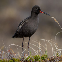
During World War II large areas of coastal East Anglia were flooded to help prevent invasion, for 100 years Avocette élégante were missing as a British breeding bird, in 1947 a very small number of Avocette élégante bred on these flooded areas for the first time, during following Winters some of those British breeding birds and continental migrants were to be found on the Tamar estuary and so it still is today. Other birds to be found in Winter are Harle huppé, Canard souchet, Canard pilet, Bernache cravant, Canard siffleur, Sarcelle d'hiver, Huîtrier pie, Pluvier doré, Barge à queue noire, Barge rousse, Bécasseau variable and Pluvier argenté, sometimes in small numbers but during periods of freezing conditions further North numbers can be greater.
From Plymouth (to the South) leave on A386 signed Tavistock, on leaving built up area road goes through moorland. Turn Left at sign Bere Alston 2 miles/Milton Combe/Lopwell/Moristow/Nature Reserve, pass over cattle grid (WARNING open moorland livestock may be in road). At next junction follow sign to Milton Combe/Bere Alston, continue on this road and pass over cattle grid (livestock no longer in road). Road starts to narrow pass straight through next crossroads signed Buckland Monachorum/Bere Alston, at next junction turn Right and immediately Left signed Buckland Mon./Bere Alston. Continue on this road and turn Left at sign 2•0m 6'-6' Bere Alston, on reaching wooded area the road gets extremely narrow with limited passing places. At bottom of hill road bends to Left and passes over narrow Denham Bridge, road climbs through woodland, at next crossroads continue straight ahead signed Bere Ferrers 3/Bere Alston. At next junction turn Left, shortly turn Left signed Bere Ferrers (Note do not enter Bere Alston), continue on this road. On passing Bere Ferrers village sign turn Right signed Station/Tamar Valley Line, turn Right signed Clamoak/Weir Quay/Hole's Hole/Station/Tamar Valley Line, turn Left at sign Station/Tamar Valley Line, road bends to Left and park beside railway station (11 spaces).
The circular route indicated on the map is about 5 km.
 ) Insérez les noms d'oiseau dans votre langue. Ils seront automatiquement traduits pour les autres usagers !
Votre feedback sera transmis à l’auteur.rice de cette zone et à l’équipe éditoriale de Birdingplaces, qui l’utiliseront pour améliorer la qualité des informations. (Vous souhaitez publier un commentaire visible en bas de page ? Fermez cette fenêtre et choisissez l’Option 1 : « Publier un commentaire, un conseil ou une observation ».)
Veuillez fournir des suggestions d'améliorations ou d'ajouts au texte de ce site ornithologique.
Veuillez fournir vos suggestions d'améliorations ou d'ajouts à la carte.
Veuillez fournir des suggestions d'améliorations ou d'ajouts à la liste des oiseaux.
Cliquez sur l'icône de l'oiseau () Insérez les noms d'oiseau dans votre langue. Ils seront automatiquement traduits pour les autres usagers !