
Beskrivning
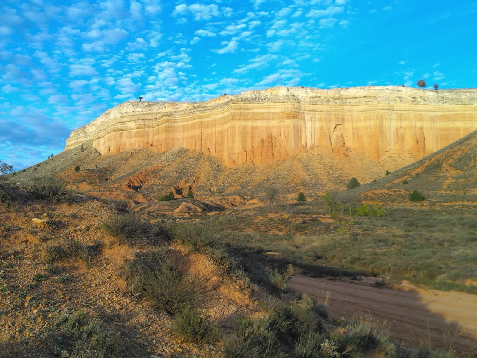
El Cañón Rojo is famous for its spectacular reddish rock formations that resemble the Grand Canyon in miniature. The canyon stretches for several kilometers, with walls up to 80 meters high. You can observe birds from diverse habitats, such as cliff-dwelling birds, steppe birds, and birds from open environments.
_________________________
Español: Podemos observar aves de diversos hábitats, como aves rupícolas, aves esteparias y aves de entornos abiertos.
Detaljer
Tillgänglighet
El Cañón Rojo is located near the small village of Villaspesa, about 5 km southwest of Teruel. To arrive to Cañón Rojo from Teruel, take the N-330 road towards Cuenca. After approximately 3.5 km, you will cross a bridge over the Rambla de Barrachina. Just after the bridge, there is a turnoff towards Villaspesa. There is space available in this area to leave the car, but it can be difficult when it rains. Press P on the map for directions to the parking. From the parking area, the walk begins by descending towards the rambla and following the path that leads into the canyon.
_________________________
Español: Para llegar al Cañón Rojo desde Teruel hay que salir por la carretera N-330 en dirección a Cuenca. Después de aproximadamente 3,5 km se cruza un puente sobre la Rambla de Barrachina. Justo después del puente, hay un desvío hacia Villaespesa. En esa zona hay espacio para aparcar el coche, pero cuando llueve puede ser complicado. Desde el aparcamiento, se inicia la caminata descendiendo hacia la rambla y siguiendo el sendero que se adentra en el cañón.
Terräng och habitat
Kanjon/klippa , StäppFörhållanden
Kulligt , Torrt , Klippigt , Öppet landskapRundtur
NejTubkikare behövs?
Kan vara användbartBästa säsong för skådning
Året runtBästa tid för ett besök
VårRutt
GrusvägHur ansträngande vandring
Lätt vandringNås
Till fotsFågeltorn / plattform
NejExtra information
Recommendations for your visit:
- Avoid summer, or at least the hottest hours of the day, as the heat can be stifling and there is no shade.
- Bring plenty of water and food if you plan to hike, especially if it's hot.
- Wear comfortable shoes with good traction, as the terrain can sometimes be a bit uneven.
- Be careful, as there are cracks, some of them deep.
- It's an open-access area, so you can visit at any time.
_________________________
Español: Hay una serie de recomendaciones para su visita:
- Evitar el verano o al menos, las horas centrales del día, ya que el calor puede ser sofocante y no hay sombra donde refugiarse.
- Llevar agua y comida suficiente si se va a hacer una caminata, sobre todo si hace calor.
- Calzado cómodo y de buen agarre, ya que a veces el terreno es un poco inestable.
- Tener cuidado, ya que hay grietas, algunas profundas.
- Es una zona de libre acceso, por lo que se puede ir en cualquier momento.


 ) Lägg till fågelnamen på ditt egna språk, namnen kommer automatiskt översättas till andra användare.