


Beskrivning
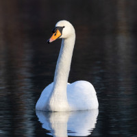
Czaplin is a beautiful place to observe wild geese and cranes, especially during migration. In spring, the areas north of the embankment (towards the Warta River) may be flooded, creating a huge pool full of water birds. On the slightly higher islands you can see impressive flocks of waders. On the southern side of the polder there are vast meadows interspersed with rows of trees and stands of willows full of birds that prefer such an environment.
In autumn, you can easily spot countless flocks of migrating geese and cranes in this area. In winter and early spring, you can see herds of deer, numbering up to 100 individuals.
________________________
Polski: Przepiękne miejsce do obserwacji dzikich gęsi i żurawi szczególnie w czasie migracji. Wiosną tereny na północ od wału ( w stronę rzeki Warta) mogą być zalane tworząc ogromne rozlewisko pełne ptaków wodnych. Na nieco wyżej położonych wysepkach można spotkać imponujące stada batalionów i innych ptaków siewkowych. Od południowej strony polderu rozciągają rozległe łąki poprzecinane rzędami drzew oraz kepami wierzb pełne ptaków preferujących takie środowisko. Jesienią łatwo spotkać w tym rejonie niezliczone stada wędrujących gęsi i zurawii.
Zimą i wczesną wiosną można spotkać stada jeleni, liczące nawet do 100 osobników.
Detaljer
Tillgänglighet
You can get there by road from Słońsk or via the Eastern Dike from the Pump Station. In my opinion, driving along the dike may be difficult (the gravel road is in poor technical condition and may be impassable after rain). It's best to get around by bike or on foot. You can leave your car near Czaplin (in safe place along the road) or at the Pump Station.
________________________
Polski: Dojechać można drogą od strony Słońska lub przejechać Wałem Wschodnim od strony Przepompowni Wody. Moim zdaniem jazda wałem może być utrudniona (szutrowa droga jest w złym stanie technicznym, a po deszczu może być nieprzejezdna). W terenie najlepiej poruszać się rowerem lub pieszo. Samochód można pozostawić w okolicach Czaplina (w bezpiecznym miejscu wzdłuż drogi) lub przy Stacji Pomp.
Terräng och habitat
Platt , Flod , Jordbruk , Spridda träd och buskar , Slätt , Gyttjig strand , Stad/by , VåtmarkFörhållanden
Platt , Ingen skugga , Öppet landskapRundtur
JaTubkikare behövs?
JaBästa säsong för skådning
Året runtBästa tid för ett besök
Vårsträck , Vår , Höst , HöststräckRutt
Bred stig , Grusväg , Smal stigHur ansträngande vandring
Genomsnittlig vandringNås
Till fots , CykelFågeltorn / plattform
NejExtra information
The observation site borders the National Park, therefore, during the period when hunting is allowed (e.g. for geese from September to December 21), on the embankment and its surroundings you may come across hunters shooting at flocks of geese flying by - it is quite a macabre sight. Unfortunately, this procedure is still legal.
When planning a visit to this place, always check the water level on the National Park website. See the link below.
________________________
Polski: Miejsce obserwacji graniczy z terenem Parku Narodowego, z tego względu w okresie kiedy polowania są dozwolone (np. na gęsi w okresie od września do 21 grudnia) na wale i jego okolicy można natknąć się mysliwych strzelających do przelatujących stad gęsi - to dość makabryczny widok. Niestety ten prodere jest wciąż legalny.
Planując wyjazd sprawdż poziom wody w okolicy na stronie Parku Narodowego Ujście Warty - link poniżej.


 ) Lägg till fågelnamen på ditt egna språk, namnen kommer automatiskt översättas till andra användare.