
Beskrivning
The Kerkini Lake is one of the youngest national parks of Greece, protected only in 2006 and inhabited by 11 amphibian, 27 reptilian, 44 mammal and 312 bird species. Beles (a.k.a. Kerkini) Mountain in the north of the park forms an over 40 kilometres long ridge that stretches from the Strymonas River to Lake Doirani, forming part of the Greek border with Bulgaria. The granitic geology gives it a "wet" character with water flowing throughout the year, and small, even large waterfalls in the ravines.
Characterized by wooded slopes, gorges, scree and bare summits, Beles is important mainly for birds of prey nesting on cliffs ( kungsörn , örnvråk , berguv , Pilgrimsfalk ) and in dense mountain forests ( svart stork , ormörn , mindre skrikörn , dvärgörn).
At low altitudes there are agricultural crops with dense hedges of hawthorn and wild rose, an area to look for balkanspett , mindre hackspett , Gröngöling , eksångare , balkansångare , balkanmes and häcksparv . Higher up are the dense forests of oak, beech, linden, chestnut, spruce and black pine with their mellanspett , gråspett , spillkråka , even the rare vitryggig hackspett . The rocky outcrops hold klippnötväcka , blåtrast , klippsparv , while the alpine vegetation at the summits is home of the stenhöna.
Detaljer
Tillgänglighet
Beles lies along the Bulgarian border, some 1 hr / 110 km north of Thessaloniki (head towards Serres, then Lake Kerkini and Lithotopos, and follow the road towards Iraklia) and 3.5 hr / 240 km south of the Bulgarian capital of Sofia. Zoom in on the map and click on the "P" (parking) sign for driving directions.
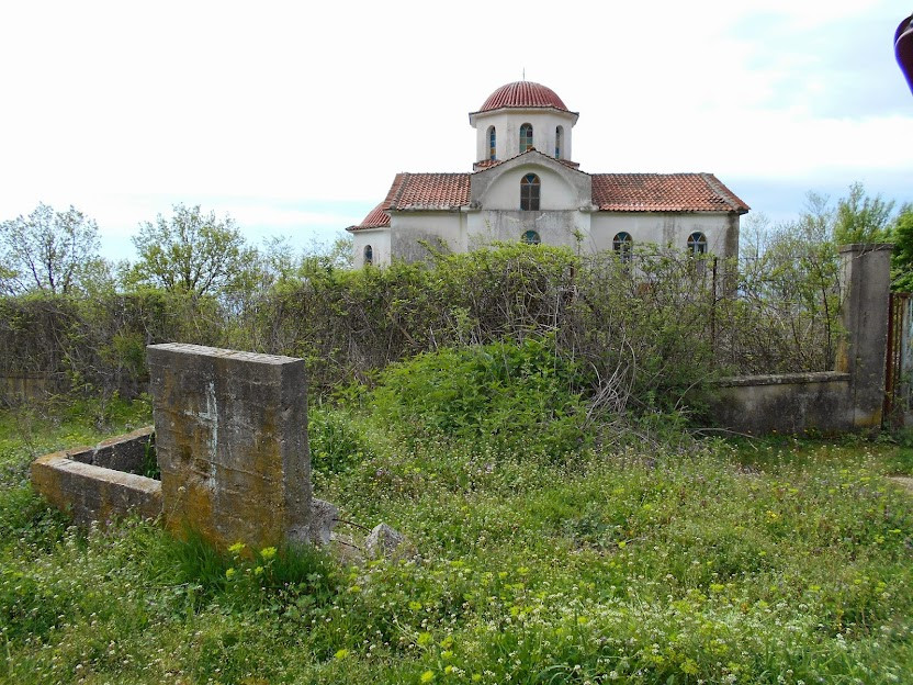
To follow the 8 km long route to the Church of Prophet Elias (3) at 500 metres a.s.l., head from the village of Vyronia, turning uphill by asphalt at the junction (1) with two cypress trees (41°15'56.09"N, 23°14'54.52"E, photos). At the right bend, turn left by a large plane tree (2) onto a dirt road and follow it to the Church of Prophet Elias ( 41°17'2.34"N, 23°12'7.76"E, photo). That section consists of fairly good if dusty macadam, but after the church the road mostly deteriorates.
While the previously described shorter western route from Vyroneia to the Church of Prophet Elias is doable in ordinary cars, the longer and higher route connecting Neo Petritsi and Vyroneia along the top ridge, reaching 1500 m a.s.l., requires a sturdy 4x4.
Terräng och habitat
Skog , Berg , Jordbruk , Spridda träd och buskar , Slätt , Kanjon/klippaFörhållanden
Bergigt , Klippigt , DammigtRundtur
NejTubkikare behövs?
Kan vara användbartBästa säsong för skådning
Vår , HöstBästa tid för ett besök
Vårsträck , Höststräck , VårRutt
Bred stig , GrusvägHur ansträngande vandring
Ansträngande vandringNås
Bil , Till fotsFågeltorn / plattform
NejExtra information
The best birding season here is spring, from mid-April to mid-June.
My accommodation of choice is the Limneo Lodge in Chrysochorafa Village, a small guesthouse with only 11 rooms (see the links below).
Mountain villages are set along streams – on hot days of summer, try refreshing yourself by the Sultanitsa stream in Neo Petritsi, offering a pleasant coolness in several taverns.
The most detailed description of the wider area is to be found in the Birdwatching in Northern Greece (2023) by Steve Mills. A shorter version is available Finding Birds in Northern Greece (2015) by Dave Gosney. Yet, none of these describes the route described above.
Länkar
- Lake Kerkini National Park authorities
- Accommodation around the lake
- Travel Guide to birdwatching sites in Greece (Lake Kerkini chapter starts at pg. 48)
- Limneo Lodge in Chrysochorafa Village
- Birding in Greece – Travel Guide to birdwatching sites in Greece (2014, pdf download) by Vlachos, Trigou & Stavrakas


 ) Lägg till fågelnamen på ditt egna språk, namnen kommer automatiskt översättas till andra användare.