


Opis
This site has two distinct environments. The town of Okehampton founded by the Saxons in 980 AD and was a centre of the wool trade, it is 21 miles from Exeter (to the East) and 24 miles from Plymouth (to the South).
The High Moors has the two highest points in Southern England: Yes Tor (2,031 foot) and High Willhays (2,039 foot). If venturing onto High Moors, BE WARNED the higher moorland has challenging terrain. EXTREME WEATHER CONDITIONS CAN HAPPEN AT ANY TIME even in summer, but especially during winter/autumn/spring. Do not venture onto higher moorland unless you have a map and compass or gps, take suitable clothing even if weather looks good. make sure you tell someone of the area you are walking and likely time of return. "Danger live firing area", the area of the High Moors walk is within a LIVE FIRING RANGE, during DAYLIGHT RED FLAGS WARN OF LIVE FIRING, at NIGHT RED LIGHTS WARN OF FIRING. Go to gov.org.uk>publications>livefirings for up to date warnings. The boundaries are marked with red and white poles and warning signs, BE AWARE during live firing observation posts watch for TRESPASSERS into the area. BE WARNED DO NOT DISTURB OR PICK UP OBJECTS WHITHIN THE RANGE DUE TO POSSIBLE LIVE MUNITIONS.
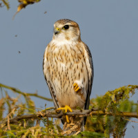
As already mentioned weather conditions can change rapidly, if so stay at lower elevations and do the River walk in Okehampton that is 1,000 foot lower than the High Moors. Pardwa mszarna once common but now extremely scarce can still be found on the High Moors, siewka złota during Winter and drozd obrożny, białorzytka świergotek łąkowy are common during Summer. At lower elevations muchołówka żałobna, pleszka, pluszcz, pliszka żółta, mysikrólik and kukułka can be found depending on season.
Szczegóły
Dostęp
The A30 Okehampton bypass runs South of the town, from Okehampton town centre head South East into George Street (opposite Okehampton Town Hall), then take third Right into Station Road, continue straight ahead (DO NOT turn Left towards Railway Station), the road (now called Tors Road) eventually crosses over the A30 bypass and heads uphill to the site. This road brings you to the RANGE WARDEN hut on Right side of road (look for Red Flag/Red Light at this point), BE AWARE the road from here on is PERMISSIVE ACCESS ONLY, if no Red Flag/Red Light proceed straight ahead over small bridge that takes you to Rowtor Car Park.
Teren i siedlisko
Rzadkie drzewa i krzewy , Las , Łąka , Dolina , Wrzosowisko , Rzeka , Miasto/wieś , Rolnictwo/uprawyWarunki
Pagórkowaty , Suchy , Otwarty krajobraz , Bagienny , PłaskiTrasa dookoła
TakCzy luneta będzie przydatna ?
Może być przydatnaUdany sezon obserwacyjny
Przez cały rokNajlepszy czas na wizytę
Wiosna , Jesień , Jesienne migracje , Wiosenne migracje , Lato , ZimaTrasa
Droga utwardzona , Droga nieutwardzona , Wąski szlak , Szeroka ścieżkaPoziom trudności szlaku pieszego
Średnio wymagający spacerDostępne
Pieszo , RowerCzatownia/platforma obserwacyjna
NieDodatkowe informacje
BE AWARE, over 40 years ago the public could drive completly around the military road in a large 'loop', but this is no longer possible due to poor state of road surface, see star on map for no unauthorised motor vehicles. Close nearby to the North East is Belstone to Taw Marsh and Belstone Cleave (see separate entry).


 ) aby wstawić nazwy ptaków w swoim języku ojczystym. Nazwy ptaków zostaną automatycznie przetłumaczone dla innych użytkowników!