Opis
A gentle 3 mile walk in an area rarely visited by birdwatchers. Membury (not to be confused with the service station of the same name on the M4 motorway) is a very remote small East Devon village, sandwiched between an ancient iron age hillfort and the River Yarty. The walk goes from the village church along 'green lanes', passing beside hedgerows sometimes in places 'alive' with birds, crossing open fields on footpaths (Be Aware livestock are very likely) to the River Yarty at Beckford Bridge, where there is an ancient Packhorse Bridge, NOTE the area near Beckford Bridge is very prone to flooding especially following prolonged heavy rain (press STAR on map).
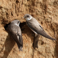
The River Yarty if the water is low is very good for czapla nadobna, czapla siwa, pluszcz, pliszka górska and zimorodek. brzegówka nest in the river banks. Follow the river North on footpath that eventually leaves the river passing Yarty Farm, the footpath goes uphill and eventually takes you back to the village.
In 2021 a bielik (G463) from the Isle of Wight Reinroduction Project spent some time in Membury area.
Szczegóły
Dostęp
The little village of Membury set amongst agricultural land has some of the narrowest roads in Devon. From the centre of Axminster, near the George Hotel (on a large traffic island), head North West on Victoria Place Road towards Market Square. In open country turn Right into Uphay Lane signed Membury, continue on this road turning Left at sign Greendown (unsuitable for heavy goods vehicles). At next junction in Membury turn Right, the car park (free) is on this road on the Right opposite the village hall.
Teren i siedlisko
Rzadkie drzewa i krzewy , Łąka , Dolina , Miasto/wieś , Rolnictwo/uprawy , RzekaWarunki
Pagórkowaty , Bagienny , Możliwy wysoki poziom wodyTrasa dookoła
TakCzy luneta będzie przydatna ?
Może być przydatnaUdany sezon obserwacyjny
Przez cały rokNajlepszy czas na wizytę
Lato , Wiosenne migracje , Jesienne migracjeTrasa
Droga utwardzona , Szeroka ścieżka , Wąski szlakPoziom trudności szlaku pieszego
Średnio wymagający spacerDostępne
Pieszo , Rower , SamochódCzatownia/platforma obserwacyjna
NieDodatkowe informacje
The village hall has a Community Cafe called the Oak Apple Cafe, unfortunately only open on Fridays between 1230-1530hrs.


