Opis
Shallow pools and a larger lake alongside the Coquet, with young woodland and reedbeds. Formerly a nature reserve managed by the gravel company that excavated the site, it was sold to a trout fishery when the gravel company was bought out around the start of this century. Despite this, it still retains some birding interest, though with access limited to a public bridleway along the south side. Hides were put in about 30 years ago but are now decaying and difficult to use; plenty of viewing points from outside though.
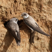
The site holds wintering wildfowl (ducks, geese, łabędź krzykliwy). czapla nadobna are frequent, and czapla biała occasional. In summer nesting waders (notably ostrygojad, brodziec piskliwy, and sieweczka obrożna; also some kulik wielki). The area also houses a brzegówka nesting colony. Otters are also present.
Szczegóły
Dostęp
Access using the B6341, running west from Rothbury, through the village of Thropton. Continue west through Hepple, crossing a bridge over the River Coquet. Take the first left turn on to unclassified road and proceed east for 2 km, to the farm at Bickerton. The bridleway is marked on left side if the road immediately after the farm. Park carefully at the side of the metalled road. Walk around 500m along bridleway.
It can also be accessed from Thropton village by following a footpath marked to the left at the west end of the village, from the B6341. Take left fork after 200 m and cross footbridge over the Coquet, then take right fork in path, passing north of farm after 1 km. The route continues west over fields with livestock, total distance 2.5 km.
Teren i siedlisko
Rzadkie drzewa i krzewy , Tereny podmokłe , Łąka , Dolina , Rzeka , Jezioro , Trzcinowiska , Rolnictwo/uprawyWarunki
Płaski , Ślisko , Możliwy wysoki poziom wody , BagiennyTrasa dookoła
NieCzy luneta będzie przydatna ?
Może być przydatnaUdany sezon obserwacyjny
Przez cały rokNajlepszy czas na wizytę
Zima , Wiosenne migracje , Jesienne migracjeTrasa
Szeroka ścieżka , Droga nieutwardzona , Wąski szlakPoziom trudności szlaku pieszego
Średnio wymagający spacerDostępne
Pieszo , Rower , SamochódCzatownia/platforma obserwacyjna
TakDodatkowe informacje
The hides are now in disrepair and few can be used as intended. View from adjecent to hides.
The bridleway is subject to flooding after heavy rain.


