

Opis
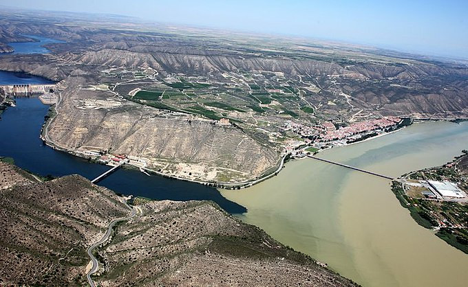
The Aiguabarreig de Mequinenza offers a striking landscape, where the large wetlands formed by the confluence of major rivers meet the surrounding arid terrain. This unique environment makes it a strategic point for many birds, serving as a wintering, breeding, or migratory stopover site. The sediment accumulation at the tail of the Ribarroja reservoir has created various islands between the confluences of the Segre and Cinca rivers, extending to the Ebro in Mequinenza.
One notable island is l’Illa dels Martinets, an important breeding colony for many heron species, including czapla złotawa, czapla nadobna, bączek, ślepowron, czapla biała, czapla siwa and czapla purpurowa. Recently, the czapla modronosa has also joined, and a few well-camouflaged bąk winter here among the reeds.
The extensive and well-preserved riparian forests and reed beds host a diverse and interesting bird population year-round. Species such as rails, woodpeckers, thrushes, tits, finches, and buntings can be seen and heard, adding to the birdwatching experience amidst lush vegetation.
In the steppe environment, you can find emblematic species like strepet, stepówka czarnobrzucha, stepówka bialobrzucha, kraska and both skowrończyk krótkopalcowy and skowrończyk mały. Transitional areas between habitats feature species like lutniczka, pokrzewka okularowa, modrak and both bialorzytka zalobna and białorzytka.
Finally, the Ebro Valley cliffs host a rich variety of cliff-dwelling species, particularly raptors, such as sęp płowy, ścierwnik, orzeł przedni, orzelek poludniowy, orzełek, gadożer, myszołów, błotniak stawowy, kania czarna, kania ruda, sokół wędrowny and puchacz.
Szczegóły
Dostęp
Aiguabarreig de Mequinenza is located in the northeastern part of Spain, where the Segre, Cinca, and Ebro rivers converge. The area can be accessed by car via the N-211 road, with parking available near the town of Mequinenza. Press a P in the map for directions. While public transport options are limited, the site can be explored by foot, bike, or car, depending on your preference. Allow at least half a day to fully appreciate the diverse habitats and bird species present.
Teren i siedlisko
Las , Tereny podmokłe , Równina , Kanion/klif , Step , Pustynia , Rzeka , Trzcinowiska , Rolnictwo/uprawy , Rzadkie drzewa i krzewy , Dolina , Miasto/wieś , ParkWarunki
Górzysty , Otwarty krajobraz , Możliwy wysoki poziom wodyTrasa dookoła
TakCzy luneta będzie przydatna ?
Może być przydatnaUdany sezon obserwacyjny
Przez cały rokNajlepszy czas na wizytę
Wiosenne migracje , Jesienne migracje , WiosnaTrasa
Droga utwardzona , Szeroka ścieżka , Droga nieutwardzonaPoziom trudności szlaku pieszego
ŁatwyDostępne
Pieszo , Rower , Samochód , ŁódźCzatownia/platforma obserwacyjna
TakDodatkowe informacje
Don't miss the museums of Mequinenza, the castle, and other cultural attractions in the area. Additionally, it's easy to find hotels, hostels, campgrounds, bars, and restaurants in the town, making your visit convenient and enjoyable (see for more info the link below).


 ) aby wstawić nazwy ptaków w swoim języku ojczystym. Nazwy ptaków zostaną automatycznie przetłumaczone dla innych użytkowników!