.JPG)
.JPG)
.JPG)
Opis
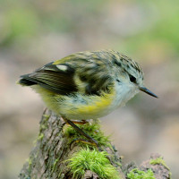
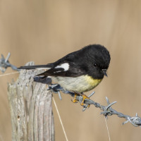
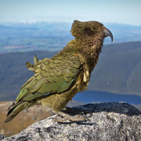
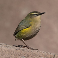
The Rob Roy Glacier Track is one of Aotearoas most beautiful day tracks, an alpine walk in the Mt Aspiring National Park. From the open flats of the Matukituki Valley, you cross a swing bridge over the West Matukituki River, then follow the gushing Rob Roy Stream as the track climbs through lush beech forest where Rifleman and Tomtit are frequently encountered. A nice place to observe them close up and in high numbers. Higher up with forest opening, you are rewarded with dramatic views of sheer cliffs, tall waterfalls, and glaciers. While not common, Kea are occasionally seen or heard in the valley. Above the treeline, in the boulder fields, there is even a chance to find Rock Wren.
Szczegóły
Dostęp
The Rob Roy Track begins at the Raspberry Creek car park, 54 km west of Wānaka on the Wānaka–Mount Aspiring Road. The last 30 km are unsealed, and the final 10 km may become unsuitable in bad weather due to creeks flooding, in particular for low-clearance cars. The drive takes about an hour. There’s a toilet at the car park and another along the track below lower and upper lookout.
About 15 minutes from the Raspberry Flat car park, the track crosses a swing bridge over the West Matukituki River, then climbs through a small gorge into beech forest. From there it leads steadily up until you get excellent views of the Rob Roy Glacier. Between the lower and upper lookout the walking path across a dry stream bed is confusing, where you ignore the unmarked track and instead head down diagonally to the orange triangle marker. The full return walk is about 10 km and takes 3–4 hours.
.JPG)
 ) aby wstawić nazwy ptaków w swoim języku ojczystym. Nazwy ptaków zostaną automatycznie przetłumaczone dla innych użytkowników!