


Opis
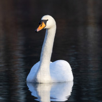
Located in the very heart of the big lake of Lac des Eaux Bleues, on a peninsula composed of many islets, marshes and a lush alluvial forest, the 50 ha Espace Nature des Grandes Vernes has been partly restored to protect, discover and observe water birds. A signposted walk begins after the car park where you enter the Espace nature des Grandes Vernes. You pass viewpoints and two bird hides. Information panels allow you to learn more about the history of the area and the Lac des Eaux Bleues that was created in the 1970s from excavations carried out by the gravel extraction industry. Among the birds you can encounter are łabędź niemy, mewa romańska, słowik rdzawy, zimorodek, czapla nadobna, perkozek, perkoz dwuczuby, kania czarna, kapturka, trzcinniczek (zwyczajny) and in winter gągoł and nurogęś.
_________________________
Français: Situé au cœur même du lac des Eaux Bleues, sur une presqu’île composée de nombreux îlots, marais et d’une luxuriante forêt alluviale, cet espace de 50 ha a été en partie restaurée pour protéger, découvrir et observer un écosystème riche et spécifique aux milieux aquatiques. La balade débute après le parking où vous pénétrez dans l’Espace nature des Grandes Vernes. Vous suivez un parcours fléché spécifique qui vous oriente vers différents lieux et aménagements pédagogiques. Des panneaux d’informations vous permettent également d’en savoir plus sur l’histoire du parc, ses fonctions et ses richesses naturelles.
Szczegóły
Dostęp
Eastern Ring Road, exit "La Rize – Parc de Miribel Jonage". At the roundabout follow the direction Parc de Miribel-Jonage and take successively the path of Machet and the alley of Vernes to the parking of Gravier Blanc. Click on the P in the map to get directions. By bus: take line 83 (Vaulx-en-Velin La Soie – Parc de Miribel Jonage, from April to September). Continue on foot on the path of the Bletta to the Fontanil car park where the access is signposted until the start of the trail (Promenade des Colverts). It takes a 15-minute walk from the bus stop to the trailhead.
_________________________
Français: En voiture : rejoignez le parc par la Rocade Est, sortie «La Rize – Parc de Miribel Jonage». Au rond-point suivez la direction Parc de Miribel-Jonage et empruntez successivement le chemin du Machet et l’allée des Vernes jusqu’au parking du Gravier Blanc. A vélo : suivez la Viarhôna depuis l’accueil du Grand Parc. En bus : empruntez la ligne 83 (Vaulx-en-Velin La Soie – Parc de Miribel Jonage, d’avril à septembre) et descendez au terminus. Poursuivez à pied sur le chemin de la Bletta jusqu’au parking du Fontanil où l’accès est fléché jusqu’au départ du sentier (promenade des Colverts). Comptez 15 minutes de marche entre l’arrêt de bus et le départ du sentier.


 ) aby wstawić nazwy ptaków w swoim języku ojczystym. Nazwy ptaków zostaną automatycznie przetłumaczone dla innych użytkowników!