Prześlij obrazy
Dozwolone typy obrazów : jpeg, png, gif
Maksymalne rozmiar to 20 MB
Path of 5.5 km around a headland. It is very varied with stretches through an old coppiced forest, along fields and on the beach at the water’s edge.
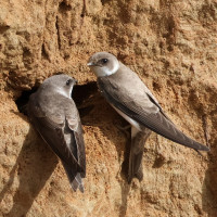
The headland is quite interesting if you manage to get round the bend as it's a nesting site for brzegówka. If you get there at high tide you might have to take the inland route, but I recommend taking the detour and walk back along the beach to see the promontory. Among the birds you can encounter along the route are bielik, ohar, gągoł, edredon, brzegówka, zimorodek, nurogęś, szlachar and śnieguła.
There are parking lots at Sandvig and at the boat club at the end of Lille Nor Vej. Click on the P in the map to get directions. On the map is shown the longer stretch, that leads you long side the water around the headland. At high tide, you may have to consider the shorter route if you want to make the tour with dry shoes.
Twoja opinia zostanie przesłana do autora tego wpisu i zespołu redakcyjnego Birdingplaces, którzy wykorzystają ją do poprawy jakości zamieszczonych informacji. Chcesz opublikować widoczny komentarz? W takim razie „odkliknij” to pole i użyj przycisku „Komentarze” znajdującego się na dole strony zawierającej opis miejsca obserwacji.
Pomóż usprawnić i poprawić informacje na temat tego „ptasiego miejsca”.
Pomóż usprawnić i poprawić informacje na temat mapy dotyczącej tego „ptasiego miejsca”.
Pomóż usprawnić i poprawić informacje na temat listy gatunków występujących na obszarze „ptasiego miejsca”. (Czy chcesz podzielić się swoimi spostrzeżeniami z innymi ? Użyj przycisku „Komentarze” znajdującego się na dole strony zawierającej opis miejsca obserwacji.)
Kliknij ikonę ptaka () aby wstawić nazwy ptaków w swoim języku ojczystym. Nazwy ptaków zostaną automatycznie przetłumaczone dla innych użytkowników!