


Opis
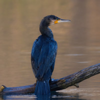
Hochter Bampd is a nice nature reserve along the river Maas/Meuse. A large part of the area is covered with riparian forests. These are forests that grow in the flood plains of rivers. There are two types of riparian forests: the softwood riparian forests with soft woods such as willow, black poplar and black alder and the hardwood riparian forests with common ash, sweet cherry, pedunculate oak and other hard woods. The grasslands in the area are rich in species and show great variation at a small distance. The zimorodek is a regular guest. Other birds you can find here are bernikla kanadyjska, Płaskonos, głowienka, kormoran, czernica, perkozek, perkoz dwuczuby, czapla biała, sieweczka rzeczna, brodziec piskliwy, makolągwa and szczygieł.
_________________________
Nederlands: Hochter Bampd is een rustig natuurgebied langs de Maas waar je vrij mag struinen. Vrijwel jaarlijks overstromen ’s winters grote delen van de Hochter Bampd. Een groot deel van het gebied is begroeid met ooibossen. Dat zijn bossen die in het overstromingsgebied van rivieren groeien. Er zijn twee soorten ooibossen: de zachthoutooibossen met zachte houtsoorten als wilg, zwarte populier en zwarte els en de hardhoutooibossen met gewone es, zoete kers, zomereik en andere harde houtsoorten. De graslanden in het gebied zijn soortenrijk en laten op kleine afstand een grote variatie zien. Op de droge zandruggen groeit bijvoorbeeld wilde marjolein, duizendblad en wondklaver. Hier en daar is zelfs ruige anjer te vinden. De zimorodek is een regelmatige gast. Andere vogels die je hier kunt aantreffen zijn bernikla kanadyjska, Płaskonos, głowienka, kormoran, czernica, perkozek, perkoz dwuczuby, czapla biała, sieweczka rzeczna, brodziec piskliwy, makolągwa en szczygieł.
Szczegóły
Dostęp
Parking is possible at Geulerweg in Neerharen. Click on the P in the map for directions. The area can only be explored on foot. The circular walking route shown on the map is about 4 km long.
_________________________
Nederlands: Parkeren kan aan de Geulerweg in Neerharen. Klik op de P in de kaart voor een routebeschrijving. Verkennen van het gebied enkel te voet. De rondwandeling zoals aangegeven op de kaart is ongeveer 4 km lang.


 ) aby wstawić nazwy ptaków w swoim języku ojczystym. Nazwy ptaków zostaną automatycznie przetłumaczone dla innych użytkowników!