.jpg)
.jpg)

Opis
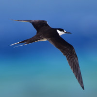
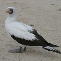
A Phillip Island boat birding trip is a 'must-do' if tours are available. Flocks of seabirds fly close overhead or roost on the Island cliffs.
Phillip Island is located 6 km south of Kingston Pier. Birds to be seen include Black-winged Petrel, Grey Ternlet, Black Noddy and Red-tailed Tropicbird.
From Wikipedia - see link: Phillip Island has an area of 190 hectares (470 acres), measuring 2.1 km (1.3 mi) from west to east and 1.95 km (1.21 mi) from north to south, with the highest point, Jacky Jacky, being 280 m (920 ft) above sea level.
It is roughly shaped like a hairdryer with the nozzle pointing east. The island is of volcanic origin, made of basaltic tuff and lava dating from the Miocene epoch.
Szczegóły
Dostęp
Charters usually depart from Kingston Pier. From Burnt Pine proceed southerly via Taylors Road, Country Road and Pier Street to arrive at the wharf. Press P on the map to access Google mapping.
Teren i siedlisko
Morze , Kanion/klifWarunki
PłaskiTrasa dookoła
TakCzy luneta będzie przydatna ?
NieUdany sezon obserwacyjny
Przez cały rokNajlepszy czas na wizytę
Lato , Wiosna , JesieńTrasa
Szeroka ścieżkaPoziom trudności szlaku pieszego
ŁatwyDostępne
ŁódźCzatownia/platforma obserwacyjna
NieDodatkowe informacje
Norfolk Island Tourism can arrange marine tour bookings - see link.
Linki
- The strait between Norfolk Island and Phillip Island is an eBird hotspot.
- Wikipedia Page.
- Norfolk Island Tourism arranges marine tour bookings.
- Bird Spots blog re NI birding.


 ) aby wstawić nazwy ptaków w swoim języku ojczystym. Nazwy ptaków zostaną automatycznie przetłumaczone dla innych użytkowników!