


Beschrijving
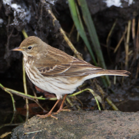
Lower Test Marshes is one of the best places to see wintering Waterpieper (double figures some years) especially from the Test Way Crossing (BE WARNED - HIGH TIDES CAN COVER THIS CROSSING). Also during Winter Smient, Wintertaling, Dodaars, Bonte Strandloper, Scholekster, Kievit, Grutto, Witgat, Tureluur, Sijs and Kleine Barmsijs, can be expected. Also the area is good for Bruine Kiekendief, Visarend, Kleine Plevier, Regenwulp, Oeverloper, Rietzanger, Kleine Karekiet, Slechtvalk (check overhead pylons), Waterral, IJsvogel, Bergeend, Rietgors, Cetti's Zanger, Gele Kwikstaart, Gekraagde Roodstaart, Beflijster and Bonte Vliegenvanger all depending on season.
The reserve has a mixture of both fresh and saltwater, with rough meadow pasture (Be Aware - livestock may be present), large reedbeds, saltmarsh, Willow (Salix) and Alder (Alnus) and some tree cover on it's Western side. The Test Way footpath/boardwalk crosses the reserve (WARNING - HIGH TIDES CAN COVER THIS CROSSING), there are 'Scrapes' with a hide and 'blinds' in the South.
For more information PRESS Stars on Map.
Details
Toegang
From the North on M271 head South to large Redbridge roundabout, near end of motorway get in Right hand lane marked A35W. After going under flyover on roundabout get in Left hand lane A35W, follow sign to Totten, (*A) after passing over Redbridge Causeway Bridge stay in Left hand lane now marked A36 signed Totten Town Centre. Continue on this road now called Commercial Road and on reaching Town Centre roundabout take third exit signed Police Station/Toilets, on passing Police Station (on Left) take next Left into Testwood Lane, Testvale Car Park (Free - But Time Restrictions Apply) is on the Left just after the Ambulance and Fire Stations. If traveling from Southampton, leave Westwards on A33, on passing over Redbridge Causeway Bridge follow from (*A) above.
For Test Way Crossing there is closer parking (Limited Spaces) near The Salmon Leap Pub (press STAR on map) near the entrance to garden allotments (Do Not Block Access).
There is a one car pull in on a bend in the North of the site. Click on a P in the map to get directions to that point.


 ) om vogelnamen snel in te voeren via een aanklikbare lijst.