Upload foto's
Toegestane afbeeldingstypen zijn jpeg, png, gif
Maximale bestandsgrootte 20MB
Path of 5.5 km around a headland. It is very varied with stretches through an old coppiced forest, along fields and on the beach at the water’s edge.
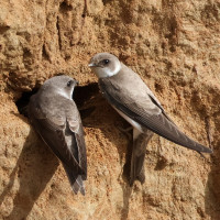
The headland is quite interesting if you manage to get round the bend as it's a nesting site for Oeverzwaluw. If you get there at high tide you might have to take the inland route, but I recommend taking the detour and walk back along the beach to see the promontory. Among the birds you can encounter along the route are Zeearend, Bergeend, Brilduiker, Eider, Oeverzwaluw, IJsvogel, Grote Zaagbek, Middelste Zaagbek and Sneeuwgors.
There are parking lots at Sandvig and at the boat club at the end of Lille Nor Vej. Click on the P in the map to get directions. On the map is shown the longer stretch, that leads you long side the water around the headland. At high tide, you may have to consider the shorter route if you want to make the tour with dry shoes.
Deze feedback wordt verzonden naar de auteur van het gebied en de redactie van Birdingplaces. Zij gebruiken de feedback om de kwaliteit van de informatie te verbeteren. Wil je een zichtbare reactie plaatsen? Klik dan dit kader weg en gebruik aub de knop 'Plaats reactie' onderaan de gebiedspagina.
Help mee de informatie en de beschrijving van dit gebied te verbeteren.
Help mee de kwaliteit van de informatie op de kaart bij dit gebied te verbeteren.
Help mee de kwaliteit van de vogellijst bij dit gebied te verbeteren. (Wil je waarnemingen delen? Klik dan dit kader weg en gebruik aub de knop 'Plaats reactie of waarnemingen' onderaan de gebiedspagina)
Klik op het vogel icoontje () om vogelnamen snel in te voeren via een aanklikbare lijst.