Descrizione
Shallow pools and a larger lake alongside the Coquet, with young woodland and reedbeds. Formerly a nature reserve managed by the gravel company that excavated the site, it was sold to a trout fishery when the gravel company was bought out around the start of this century. Despite this, it still retains some birding interest, though with access limited to a public bridleway along the south side. Hides were put in about 30 years ago but are now decaying and difficult to use; plenty of viewing points from outside though.
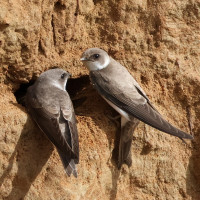
The site holds wintering wildfowl (ducks, geese, Cigno selvatico). Garzetta are frequent, and Airone bianco maggiore occasional. In summer nesting waders (notably Beccaccia di mare, Piro piro piccolo, and Corriere grosso; also some Chiurlo maggiore). The area also houses a Topino nesting colony. Otters are also present.
Dettagli
Accesso
Access using the B6341, running west from Rothbury, through the village of Thropton. Continue west through Hepple, crossing a bridge over the River Coquet. Take the first left turn on to unclassified road and proceed east for 2 km, to the farm at Bickerton. The bridleway is marked on left side if the road immediately after the farm. Park carefully at the side of the metalled road. Walk around 500m along bridleway.
It can also be accessed from Thropton village by following a footpath marked to the left at the west end of the village, from the B6341. Take left fork after 200 m and cross footbridge over the Coquet, then take right fork in path, passing north of farm after 1 km. The route continues west over fields with livestock, total distance 2.5 km.
Terreno e habitat
Alberi e cespugli sparsi , Zona umida , Prateria/pascolo , Valle , Fiume , Lago , Canneti , Terreni coltivatiCaratteristiche dell’area
Terreno piano , Scivoloso , Acqua alta possibile , PaludosoPercorso ad anello
NoÈ utile un cannocchiale?
Può essere utileBuona stagione per il BW
Tutto l'annoMiglior periodo per visitare
Inverno , Migrazione primaverile , Migrazione autunnalePercorso
Sentiero ampio , Strada sterrata , Sentiero strettoGrado di difficoltà del percorso a piedi
Difficoltà mediaModalità di accesso
A piedi , Bicicletta , MacchinaCapanno/torretta di osservazione
SiInformazioni aggiuntive
The hides are now in disrepair and few can be used as intended. View from adjecent to hides.
The bridleway is subject to flooding after heavy rain.


