

Descrizione
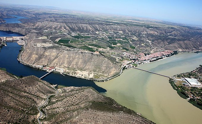
The Aiguabarreig de Mequinenza offers a striking landscape, where the large wetlands formed by the confluence of major rivers meet the surrounding arid terrain. This unique environment makes it a strategic point for many birds, serving as a wintering, breeding, or migratory stopover site. The sediment accumulation at the tail of the Ribarroja reservoir has created various islands between the confluences of the Segre and Cinca rivers, extending to the Ebro in Mequinenza.
One notable island is l’Illa dels Martinets, an important breeding colony for many heron species, including Airone guardabuoi, Garzetta, Tarabusino, Nitticora, Airone bianco maggiore, Airone cenerino and Airone rosso. Recently, the Sgarza ciuffetto has also joined, and a few well-camouflaged Tarabuso winter here among the reeds.
The extensive and well-preserved riparian forests and reed beds host a diverse and interesting bird population year-round. Species such as rails, woodpeckers, thrushes, tits, finches, and buntings can be seen and heard, adding to the birdwatching experience amidst lush vegetation.
In the steppe environment, you can find emblematic species like Gallina prataiola, Ganga, Grandule, Ghiandaia marina and both Calandrella and Calandrina. Transitional areas between habitats feature species like Bigia grossa, Sterpazzola della Sardegna, Passero solitario and both Monachella nera and Culbianco.
Finally, the Ebro Valley cliffs host a rich variety of cliff-dwelling species, particularly raptors, such as Grifone, Capovaccaio, Aquila reale, Aquila di Bonelli, Aquila minore, Biancone, Poiana, Falco di palude, Nibbio bruno, Nibbio reale, Falco pellegrino and Gufo reale.
Dettagli
Accesso
Aiguabarreig de Mequinenza is located in the northeastern part of Spain, where the Segre, Cinca, and Ebro rivers converge. The area can be accessed by car via the N-211 road, with parking available near the town of Mequinenza. Press a P in the map for directions. While public transport options are limited, the site can be explored by foot, bike, or car, depending on your preference. Allow at least half a day to fully appreciate the diverse habitats and bird species present.
Terreno e habitat
Foresta , Zona umida , Pianura , Canyon/scogliera , Steppa , Deserto , Fiume , Canneti , Terreni coltivati , Alberi e cespugli sparsi , Valle , Città/paese , ParcoCaratteristiche dell’area
Montagnoso , Paesaggio aperto , Acqua alta possibilePercorso ad anello
SiÈ utile un cannocchiale?
Può essere utileBuona stagione per il BW
Tutto l'annoMiglior periodo per visitare
Migrazione primaverile , Migrazione autunnale , PrimaveraPercorso
Strada asfaltata , Sentiero ampio , Strada sterrataGrado di difficoltà del percorso a piedi
FacileModalità di accesso
A piedi , Bicicletta , Macchina , BarcaCapanno/torretta di osservazione
SiInformazioni aggiuntive
Don't miss the museums of Mequinenza, the castle, and other cultural attractions in the area. Additionally, it's easy to find hotels, hostels, campgrounds, bars, and restaurants in the town, making your visit convenient and enjoyable (see for more info the link below).


 ) per inserire i nomi delle specie nella tua lingua. I nomi delle specie verranno automaticamente tradotti per gli altri utenti!