

Descrizione
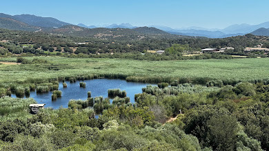
Etang de Tanchiccia is a lake with surrounding wetlands that is fed only by the autumn and winter floods of the Taravo. The Tanchiccia pond displays a maximum filling from the beginning of winter. It then gradually empties in the spring to be almost completely dry by the end of summer. These different water levels attract many birds. No less than 148 species of birds have been counted there to date, including the 9 European herons. In addition, the Tanchiccia reed bed is the largest reed bed in South Corsica. Visitors can explore the area from wooden pontoons and observation posts. The 10 meter high watchtower has fantastic panoramic views of the sea, lake and surrounding countryside, like a 180-degree mosaic of green meadows, scrubland and water, framed by the mountains in the distance. Among the birds you can see are Airone rosso, Airone guardabuoi, Tarabusino, Cavaliere d'Italia, Falco di palude, Tuffetto, Balestruccio, Forapaglie castagnolo, Cannareccione, Occhiocotto and Martin pescatore.
_________________________
Français: L’étang de Tanchiccia, d’une superficie de 28 ha, est propriété de la Collectivité de Corse. Il est situé sur la Commune de Serra di Ferro et intégré dans un Espace Naturel Sensible d'une superficie de 80ha; cet espace est inventorié au titre des Zones Naturelles d’Intérêt Ecologique Faunistique et Floristique de type 1 (ZNIEFF type 1) et inscrit au réseau des zones Natura 2000 ainsi qu'aux espaces remarquables du littoral. Nourri uniquement par les crues automnales et hivernales du Taravo, l’étang de Tanchiccia affiche un remplissage maximum dès le début de l’hiver. Il se vide ensuite progressivement au printemps pour être presque complètement à sec à la fin de l’été. Par ailleurs, la roselière de Tanchiccia constitue la plus vaste roselière de Corse-du-Sud ! Ponctuée de collections d’eau, de mares et d’anciens canaux de drainage, elle est un lieu calme et attractif pour une grande diversité d’espèces animales, notamment les oiseaux.
Dettagli
Accesso
The site is easily accessible since it is adjacent to the D757, direction Porto-Pollo. There is a 3km walking trail marked with wooden signs. Information panels are positioned all along the walking trail, providing information on the flora and fauna. The route does not present any particular difficulties, a path on stilts of 274 meters with an observatory of 35 m² is also accessible to people with reduced mobility.
_________________________
Français: Tout d’abord, le site est facilement accessible puisqu’il est attenant à la départementale D757, direction Porto-Pollo. Ensuite, le parcours ne présente pas de difficultés particulières, un sentier sur pilotis de 274 mètres linaires avec un observatoire de 35 m² est également accessible aux personnes à mobilité réduite.


 ) per inserire i nomi delle specie nella tua lingua. I nomi delle specie verranno automaticamente tradotti per gli altri utenti!