


Charger images
Les formats d'image autorisés sont de type jpeg, png ou gif
La taille maximale du fichier doit être de 20MB
, CC BY 4.0 httpscreativecommons.orglicensesby4.0, via Wikimedia Commons.jpg)

Sweden´s largest forest national park with intact primeval forests with giant long-boled pines, mosaics of marshland, waterfalls and canyons.
Muddus National Park is one of the quietest places in Sweden, part of Laponia, and a Unesco World Heritage Site. The national park is consisting of forests, lakes and marshes largely on a plateau bisected by a valley, broad in the north but passing through narrow gorges in the south. The park has mainly old-growth forest and large boggy grounds. The forest has a lot of old large trees, consisting mainly of pine and spruce with some birch and willow.
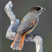
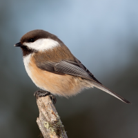
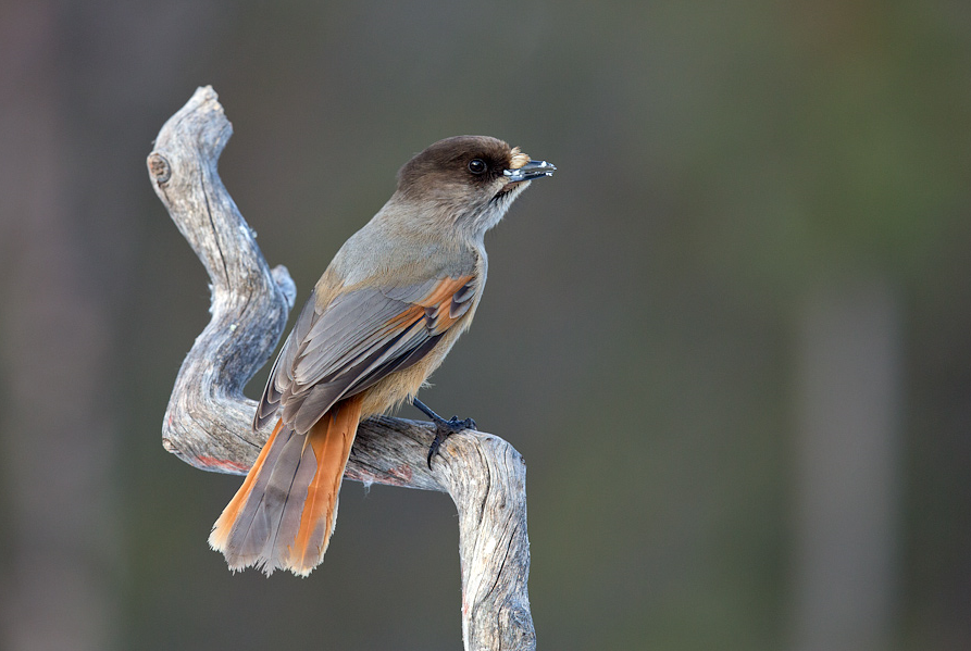
Due to the intact primeval forests the area has a large boreal bird community. In the forest you can encounter birds like Gélinotte des bois, Tétras lyre, Grand Tétras, Mésangeai imitateur, Durbec des sapins, Pic tridactyle and Mésange lapone. Owls that can be spotted include Chevêchette d'Europe, Chouette de l'Oural, Chouette épervière, Grand-duc d'Europe and Chouette de Tengmalm. Raptors that can be seen include Aigle royal, Busard Saint-Martin, Balbuzard pêcheur and Faucon pèlerin. On the lakes you can observe Cygne chanteur, Garrot à oeil d'or and Plongeon arctique. In the marshes of the park you can spot Grue cendrée, Chevalier sylvain, Bécasseau variable, Chevalier aboyeur and Bécassine des marais.
Muddus is also known for its mammals. Within the boundaries of the national park live Brown Bear, Wolverine, Lynx, Pine Marten, Otter, Reindeer, Moose and Beaver.
Muddus national park is located in Sweden's far north, 20 km north of the town of Jokkmokk. The easiest way to get there is by car from Jokkmokk, passing the dam of the Luleälven hydroelectric power station (Vattenkrafverk Ligga) near the village of Ligga, and from there to the parking at the entrance. Press P on the map for directions to the parking.
In Muddus national park there is a summer trail system approximately 50 km long. The hiking trail makes it easy to explore large parts of the national park. But the distances can be long and there can be a lot of mosquitoes in the summer, so make sure you are prepared. The long 46 km trail that is indicated on the map is a path that follows ancient migratory routes, passing by five cabins with sleeping accommodations that are open year-round. But of course you can also do just a part of the trail or the 4 km circular walk at the beginning of the trail.
 ) Insérez les noms d'oiseau dans votre langue. Ils seront automatiquement traduits pour les autres usagers !
Votre feedback sera transmis à l’auteur.rice de cette zone et à l’équipe éditoriale de Birdingplaces, qui l’utiliseront pour améliorer la qualité des informations. (Vous souhaitez publier un commentaire visible en bas de page ? Fermez cette fenêtre et choisissez l’Option 1 : « Publier un commentaire, un conseil ou une observation ».)
Veuillez fournir des suggestions d'améliorations ou d'ajouts au texte de ce site ornithologique.
Veuillez fournir vos suggestions d'améliorations ou d'ajouts à la carte.
Veuillez fournir des suggestions d'améliorations ou d'ajouts à la liste des oiseaux.
Cliquez sur l'icône de l'oiseau () Insérez les noms d'oiseau dans votre langue. Ils seront automatiquement traduits pour les autres usagers !