


Charger images
Les formats d'image autorisés sont de type jpeg, png ou gif
La taille maximale du fichier doit être de 20MB


Nature trail in in Polesie National Park through wetlands, forests and peat bogs. An ideal place for many species of wetland birds.
Czahary means 'wetland covered with shrubs'. The trail leads through Bagno Bubnów - the largest peat bog of Polesie National Park. The trail runs through open areas of low peatbogs, and partly through diverse forests surrounding the peatbog.
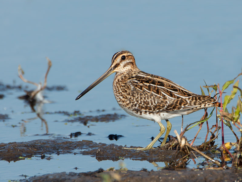
Along the trail you can see many species of wetland birds such as Courlis cendré, Bécassine des marais, Barge à queue noire, Marouette ponctuée and Busard des roseaux. It is also a great place for observing Grue cendrée. Their autumn gatherings are among the largest in the region. Over 3,000 individuals can gather here for spending nights. There is another rare bird species that birders look for here: Phragmite aquatique. The population in Polesie NP is stable and is estimated at about 400 singing males - this is the second largest population in Poland. Other interesting birds you can encounter in the area are Tarier des prés, Phragmite des joncs, Butor étoilé, Loriot d'Europe, Pie-grièche écorcheur and Locustelle luscinioïde.
The observation site is located in the National Park - entry tickets are required. Tickets can be purchased at the Park's branches or via the website - necessary links below.
________________________
Polski: Ścieżka dydaktyczna „Czahary” to pierwsza trasa PPN prowadząca przez tereny Bagna Bubnów. Dzięki drewnianym kładkom możemy poznać niezwykłe tajemnice torfowisk. Na trasie spotkamy wiele udogodnień - wieże i platformy widokowe oraz zadaszenia turystyczne. Dzięki ścieżce „Czahary” mamy okazję poznać niezwykłego mieszkańca Polesia - wodniczkę. Ten niepozorny ptak z rodziny trzciniaków jest najmniejszym migrującym ptakiem Europy. Teren Poleskiego Parku Narodowego. Ścieżka Czahary (wstęp płatny w PPN). Na trasie kilka wież obserwacyjnych.
Miejsce obserwacji znajduje się na terenie Parku Narodowego - konieczny zakup biletów wstępu. Bilety można kupić w placówkach Parku lub poprzez stronę internetową - konieczne i potrzebne linki poniżej w treści.
The trail begins and ends behind the village of Zastawie, by an observation tower. However, the trail is also accessible in Kulczyn and Wincencin. Click on a P in the map for directions to a parking. Accessible by car or bike. The circular walk indicated on the map is about 6 km.
The wooden footbridges on the path are accessible for wheelchairs and strollers - details on the National Park map (see link).
________________________
Polski: Do ścieżki dotrzemy następującymi drogami: 1. Od Urszulina po niecałych 2 km w kierunku Wereszczyna skręcamy w lewo (kierunek Zastawie) i po 3,5 km jesteśmy przy wieży widokowej w Zastawiu na początku ścieżki. 2. Od Hańska w kierunku Urszulina, w Kulczynie na południe w kierunku Pikulawki, dalej na zachód drogą przez Pikulawkę do miejsca postojowego. 3. Od Urszulina w kierunku Hańska, w Wincencinie na południe drogą gruntową do miejsca postojowego. Dojazd samochodem lub rowerem. Parking na miejscu.
Drewniane kładki znajdujące się na ścieżce dostępne są dla wózków inwalidzkich i wózków dziecięcych- szczegóły na mapie Parku Narodowego (patrz link).
 ) Insérez les noms d'oiseau dans votre langue. Ils seront automatiquement traduits pour les autres usagers !
Votre feedback sera transmis à l’auteur.rice de cette zone et à l’équipe éditoriale de Birdingplaces, qui l’utiliseront pour améliorer la qualité des informations. (Vous souhaitez publier un commentaire visible en bas de page ? Fermez cette fenêtre et choisissez l’Option 1 : « Publier un commentaire, un conseil ou une observation ».)
Veuillez fournir des suggestions d'améliorations ou d'ajouts au texte de ce site ornithologique.
Veuillez fournir vos suggestions d'améliorations ou d'ajouts à la carte.
Veuillez fournir des suggestions d'améliorations ou d'ajouts à la liste des oiseaux.
Cliquez sur l'icône de l'oiseau () Insérez les noms d'oiseau dans votre langue. Ils seront automatiquement traduits pour les autres usagers !