

Charger images
Les formats d'image autorisés sont de type jpeg, png ou gif
La taille maximale du fichier doit être de 20MB
_0.jpg)
.jpg)
.jpg)
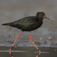
The Tasman River Delta at the head of Lake Pukaki is the best place to see one of the world's rarest waders - the critically endangered Kakī Black Stilt.
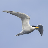
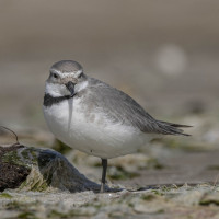
The Tasman River Delta, stretching between Aoraki/Mount Cook and Lake Pukaki, is a vast braided riverbed of shingle channels, wetlands, and scrubby flats. It’s a primary stronghold of the critically endangered Kakī Black Stilt, a species once on the brink of extinction and now recovering through intensive conservation. This is probably the most reliable place to see them in the wild. They’re typically found foraging in shallow channels, often near other species such as Double-banded Plover, South Island Oystercatcher, and Wrybill. Black-fronted Tern and Black-billed Gull breed on the river and are around from October to March.
The open landscape also supports Swamp Harrier, Australian Pipit, and several species of waterfowl. The delta's scale and isolation, with Aoraki rising behind it, make this a uniquely scenic and rewarding spot for birders. The habitat is highly dynamic, with river channels shifting and lake levels fluctuating throughout the year. A consistently productive area is the small access road and track just after Glentanner Airport, which leads to the Lake Pukaki shoreline - often a good place to find Black Stilt. Alternatively, ponds visible from pull-outs along Tasman Valley Road can also be worth scanning.
The main birding area is reached via a short gravel access road on the lake side of the highway, just where the Glentanner Airport fence ends. From there, it's typically a 250 m walk (distance varies with water levels) to reach the lake edge and mudflats where waders and Kakī can often be seen.
This spot is about 23 km from Aoraki/Mount Cook Village (20 min drive) and 45 km from Twizel (30 min). There are also several pull-outs along Tasman Valley Road that offer views of ponds and side channels.
Keep in mind that this is a mountain region, and access may be limited or unsafe in winter due to snow, ice, or flooding. Check the local forecast and road conditions before travelling.
 ) Insérez les noms d'oiseau dans votre langue. Ils seront automatiquement traduits pour les autres usagers !
Votre feedback sera transmis à l’auteur.rice de cette zone et à l’équipe éditoriale de Birdingplaces, qui l’utiliseront pour améliorer la qualité des informations. (Vous souhaitez publier un commentaire visible en bas de page ? Fermez cette fenêtre et choisissez l’Option 1 : « Publier un commentaire, un conseil ou une observation ».)
Veuillez fournir des suggestions d'améliorations ou d'ajouts au texte de ce site ornithologique.
Veuillez fournir vos suggestions d'améliorations ou d'ajouts à la carte.
Veuillez fournir des suggestions d'améliorations ou d'ajouts à la liste des oiseaux.
Cliquez sur l'icône de l'oiseau () Insérez les noms d'oiseau dans votre langue. Ils seront automatiquement traduits pour les autres usagers !