 Dotterel - Charadrius obscurus.jpg)

.JPG)
Charger images
Les formats d'image autorisés sont de type jpeg, png ou gif
La taille maximale du fichier doit être de 20MB
.JPG)
.JPG)
.JPG)
Volcanic island in Auckland's Hauraki Gulf where coastal lava fields transititioning to native forest up the peek. Accessible by ferry with scenic tracks.
Rangitoto Island is Auckland's youngest and largest volcanic cone, rising 260 metres from the Hauraki Gulf. The island's landscape is dominated by rugged lava fields colonised by New Zealand's largest pōhutukawa forest, along with coastal scrub and regenerating native bush. This unique habitat mosaic supports a recovering bird community following extensive pest eradication efforts.
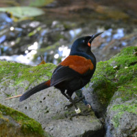
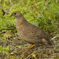
The island is particularly good for observing coastal and forest birds, including many endemics for whom it is a pest-free sanctuary. Forest residents include Whitehead, North Island Saddleback, New Zealand Bellbird and Red-crowned Parakeet. The island is also a good place to see Brown Quail. At McKenzie Bay Beach, which lies in the Northwestern corner of the long circular trail, is a good spot for New Zealand Dotterel; the Shore Plover released on Motutapu Island can sometimes be found at the causeway in the East. Along the coastline and in the surrounding waters, look for White-fronted Tern, Silver Gull, Kelp Gull, White-faced Heron (and occasionally Eastern Reef Egret), and shags.
Rangitoto should probably be on any Auckland visitor's itinerary - it's not just about the birds. The viewing platform on the top offers a stunning 360-degree panaroma across the Hauraki Gulf and Auckland's skyline. Also just the volcano cone, the forest, and the lava caves to explore along the direct summit trail are worth it. Thanks to intensive pest eradication efforts completed in the 2010s, native bird populations have rebounded dramatically.
Rangitoto Island is located in Auckland's Hauraki Gulf, approximately 8 kilometres northeast of the city centre. The island is accessible only by ferry operated by Fullers360, departing from downtown Auckland (Ferry Building) or Devonport, with journey times of approximately 30 minutes. Ferry services run a bit earlier and leave a bit later on weekends and public holidays, giving you more time to explore the island.
The island is explored on foot via walking tracks. The direct summit track to the crater takes approximately 1h each way and is moderately steep but well-maintained; the lava caves are located along this route. Alternatively, take one of the longer loop tracks such as the one via McKenzie Bay (2,5h from Wharf, then 1,5h to summit) that follows the coast before ascending the mountain.
If planning to walk to the causeway to look for Shore Plover, note that the return journey to the ferry wharf takes 1.5-2h, so plan ahead to avoid missing the last ferry back.
Allow 4-6h for a visit including walking and birding time. Bring water, sun protection, and snacks as there are no facilities on the island. Sturdy footwear is essential for the rough lava rock terrain.
 ) Insérez les noms d'oiseau dans votre langue. Ils seront automatiquement traduits pour les autres usagers !
Votre feedback sera transmis à l’auteur.rice de cette zone et à l’équipe éditoriale de Birdingplaces, qui l’utiliseront pour améliorer la qualité des informations. (Vous souhaitez publier un commentaire visible en bas de page ? Fermez cette fenêtre et choisissez l’Option 1 : « Publier un commentaire, un conseil ou une observation ».)
Veuillez fournir des suggestions d'améliorations ou d'ajouts au texte de ce site ornithologique.
Veuillez fournir vos suggestions d'améliorations ou d'ajouts à la carte.
Veuillez fournir des suggestions d'améliorations ou d'ajouts à la liste des oiseaux.
Cliquez sur l'icône de l'oiseau () Insérez les noms d'oiseau dans votre langue. Ils seront automatiquement traduits pour les autres usagers !