


Charger images
Les formats d'image autorisés sont de type jpeg, png ou gif
La taille maximale du fichier doit être de 20MB


Their remarkable colour effect reportedly results from the oxidation of iron within the rock millions of years ago.
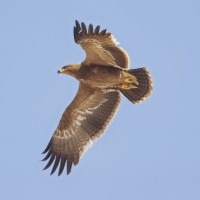
The staggering pink-and-white slopes of the Caucasus mountain foothills in the Khizi region have earned them the name of the “Candy Cane Mountains”. The area is known for several species of lower mountain habitats and it is a nice side trip during a spring visit to Besh Barmag or a drive between Baku and the Greater Caucasus Mountains. Among the birds you can encounter in the area are Sittelle des rochers, Perdrix choukar, Bruant mélanocéphale, Rossignol siffleur, Aigle des steppes, Faucon lanier, Traquet de Finsch, Étourneau roselin, Rollier d'Europe, Pie-grièche à tête rousse, Vautour percnoptère, Black Vulture, Vautour fauve and Faucon crécerellette.
One of Azerbaijan’s most beautiful stretches of road leads for about 40 kilometres from the Guba-Baku highway west towards the mountain village of Altiaghaj. Roughly mid-way between the two one passes through a dramatic valley flanked by rolling shale mountains whose astonishing red, orange, pink and chalk-coloured swirls led British travel writer Mark Elliott (author of the very popular 'Azerbaijan' guidebook) to dub them the Candy Cane Mountains, a name that’s stuck with travellers ever since. The astonishing colours are said to be due to groundwater that’s altered the oxidation state of iron compounds within the rock. If taking an organised hike here, which can be booked through tour companies in Baku and is preferably undertaken in autumn or spring, glance down beneath your feet: you may discover tiny fossils and perhaps even a squid-like belemnite from the cretaceous period.
The corridor between the mountains and the sea is a birdwatching site of global significance and you can climb from here to the top of Beshbarmag Mountain to witness stunning views and intriguing spiritual rituals.
 ) Insérez les noms d'oiseau dans votre langue. Ils seront automatiquement traduits pour les autres usagers !
Votre feedback sera transmis à l’auteur.rice de cette zone et à l’équipe éditoriale de Birdingplaces, qui l’utiliseront pour améliorer la qualité des informations. (Vous souhaitez publier un commentaire visible en bas de page ? Fermez cette fenêtre et choisissez l’Option 1 : « Publier un commentaire, un conseil ou une observation ».)
Veuillez fournir des suggestions d'améliorations ou d'ajouts au texte de ce site ornithologique.
Veuillez fournir vos suggestions d'améliorations ou d'ajouts à la carte.
Veuillez fournir des suggestions d'améliorations ou d'ajouts à la liste des oiseaux.
Cliquez sur l'icône de l'oiseau () Insérez les noms d'oiseau dans votre langue. Ils seront automatiquement traduits pour les autres usagers !