


Charger images
Les formats d'image autorisés sont de type jpeg, png ou gif
La taille maximale du fichier doit être de 20MB
.jpg)
.jpg)

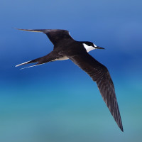
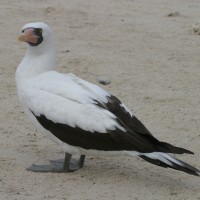
A Phillip Island boat birding trip is a 'must-do' if tours are available. Flocks of seabirds fly close overhead or roost on the Island cliffs.
A Phillip Island boat birding trip is a 'must-do' if tours are available. Flocks of seabirds fly close overhead or roost on the Island cliffs.
Phillip Island is located 6 km south of Kingston Pier. Birds to be seen include Black-winged Petrel, Grey Ternlet, Black Noddy and Red-tailed Tropicbird.
From Wikipedia - see link: Phillip Island has an area of 190 hectares (470 acres), measuring 2.1 km (1.3 mi) from west to east and 1.95 km (1.21 mi) from north to south, with the highest point, Jacky Jacky, being 280 m (920 ft) above sea level.
It is roughly shaped like a hairdryer with the nozzle pointing east. The island is of volcanic origin, made of basaltic tuff and lava dating from the Miocene epoch.
Charters usually depart from Kingston Pier. From Burnt Pine proceed southerly via Taylors Road, Country Road and Pier Street to arrive at the wharf. Press P on the map to access Google mapping.
Norfolk Island Tourism can arrange marine tour bookings - see link.
 ) Insérez les noms d'oiseau dans votre langue. Ils seront automatiquement traduits pour les autres usagers !
Votre feedback sera transmis à l’auteur.rice de cette zone et à l’équipe éditoriale de Birdingplaces, qui l’utiliseront pour améliorer la qualité des informations. (Vous souhaitez publier un commentaire visible en bas de page ? Fermez cette fenêtre et choisissez l’Option 1 : « Publier un commentaire, un conseil ou une observation ».)
Veuillez fournir des suggestions d'améliorations ou d'ajouts au texte de ce site ornithologique.
Veuillez fournir vos suggestions d'améliorations ou d'ajouts à la carte.
Veuillez fournir des suggestions d'améliorations ou d'ajouts à la liste des oiseaux.
Cliquez sur l'icône de l'oiseau () Insérez les noms d'oiseau dans votre langue. Ils seront automatiquement traduits pour les autres usagers !