


Beschreibung
The Bere Peninsula has the River Tamar estuary on it's Western side and the River Tavy estuary on it's South Eastern side. The site was known for Tin, Silver Lead Ore and Arsenic mining in the past and more recently better known for fruit and flower production. The walk starts by the railway station in Bere Ferrers (Bere here meaning a woodland for pigs), crossing farm fields (livestock may be present) to Thorn Point giving wide views of the Tamar estuary. The walk continues along farm wooded hedges and finishes by returning along a quiet narrow road back to the start point.
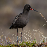
During World War II large areas of coastal East Anglia were flooded to help prevent invasion, for 100 years Säbelschnäbler were missing as a British breeding bird, in 1947 a very small number of Säbelschnäbler bred on these flooded areas for the first time, during following Winters some of those British breeding birds and continental migrants were to be found on the Tamar estuary and so it still is today. Other birds to be found in Winter are Mittelsäger, Löffelente, Spießente, Ringelgans, Pfeifente, Krickente, Austernfischer, Goldregenpfeifer, Uferschnepfe, Pfuhlschnepfe, Alpenstrandläufer and Kiebitzregenpfeifer, sometimes in small numbers but during periods of freezing conditions further North numbers can be greater.
Details
Zugang
From Plymouth (to the South) leave on A386 signed Tavistock, on leaving built up area road goes through moorland. Turn Left at sign Bere Alston 2 miles/Milton Combe/Lopwell/Moristow/Nature Reserve, pass over cattle grid (WARNING open moorland livestock may be in road). At next junction follow sign to Milton Combe/Bere Alston, continue on this road and pass over cattle grid (livestock no longer in road). Road starts to narrow pass straight through next crossroads signed Buckland Monachorum/Bere Alston, at next junction turn Right and immediately Left signed Buckland Mon./Bere Alston. Continue on this road and turn Left at sign 2•0m 6'-6' Bere Alston, on reaching wooded area the road gets extremely narrow with limited passing places. At bottom of hill road bends to Left and passes over narrow Denham Bridge, road climbs through woodland, at next crossroads continue straight ahead signed Bere Ferrers 3/Bere Alston. At next junction turn Left, shortly turn Left signed Bere Ferrers (Note do not enter Bere Alston), continue on this road. On passing Bere Ferrers village sign turn Right signed Station/Tamar Valley Line, turn Right signed Clamoak/Weir Quay/Hole's Hole/Station/Tamar Valley Line, turn Left at sign Station/Tamar Valley Line, road bends to Left and park beside railway station (11 spaces).
Terrain und Habitat
Vereinzelte Bäume und Büsche , Grasland, Wiesen , Tal , Fluss , Stadt/Dorf , Landwirtschaft , Schlammflächen , Strand , WaldBedingungen
Flach , Hügelig , Felsig , Offene Landschaft , Hochwasser möglich , Rutschig , SumpfigRundweg
JaIst ein Spektiv nützlich?
JaGute Beobachtungszeit
GanzjährigBeste Beobachtungszeit
Winter , Frühjahrszug , Frühjahr , Herbst , HerbstzugRoute
asphaltierte Straße , Normaler Weg , unbefestigte Straße , Schmaler PfadSchwierigkeitsgrad der Tour
DurchschnittlichErreichbarkeit
zu Fuß , Fahrrad , AutoBeobachtungshütten oder -türme
NeinZusätzliche Informationen
The circular route indicated on the map is about 5 km.


.jpg)
 ) Tragen Sie die Vogelnamen in Ihrer Sprache ein. Sie werden automatisch für andere Nutzer übersetzt!