

Description
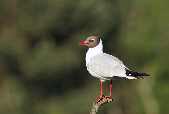
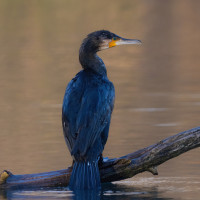
Eco Site du Val Renoux is a lake surrounded with varied vegetation (orchards, willows, etc.). The diverse habitats attract many birds. You can make a circular walk of 2 km around the lake. Three observatories are located along the route. Birds you can observe include Silkehejre, Skarv, Taffeland, Troldand and Sølvhejre.
________________________
Français: Situé sur une ancienne carrière, ce site de 25 hectares a été reconverti en Eco site pour allier espaces naturels, faune et développement durable. Son étang de 10 ha et sa végétation variée (vergers, saules…) favorise l’accueil d’oiseaux. trois observatoires sont disposés le long du parcours.
Details
Access
Eco Site du Val Renoux is located just west of the village of Sotteville-sous-le-Val. Press P on the map for directions. On the A13 motorway take the Tourville la rivière exit. Continue on the road for 65 metres. Tourville-la-RivièrePont-de-l'ArcheAirport. At the roundabout, take the 2nd exit onto D7 and continue for 500 metres. At the roundabout, take the 1st exit onto D7 and continue for 450 metres, RouenCaenOissel. At the roundabout, take the 1st exit onto D292 (Rue Danielle Casanova) and continue for 120 metres. Turn right onto D292 (Rue Danielle Casanova) and continue for 160 metres. Turn slightly right onto D292 (Rue Camille Saint-Saëns) and continue for 900 metres. Turn slightly right onto the lane and continue for 550 meters. Turn right onto D92 and continue for 300 meters. The entrance is on your left. Possibility to walk around the lake (2 km).
________________________
Français: Sur l’autoroute A13 prendre la sortie Tourville la rivière. Continuer la voie sur 65 mètres. Tourville-la-RivièrePont-de-l'ArcheAéroport, 9,7 km. Au rond-point, prendre la 2ème sortie sur D7 et continuer sur 500 mètres, 9,8 km. Au rond-point, prendre la 1ère sortie sur D7 et continuer sur 450 mètres, RouenCaenOissel, 10,3 km. Au rond-point, prendre la 1ère sortie sur D292 (Rue Danielle Casanova) et continuer sur 120 mètres, 10,8 km. Tourner à droite sur D292 (Rue Danielle Casanova) et continuer sur 160 mètres, 10,9 km. Tourner légèrement à droite sur D292 (Rue Camille Saint-Saëns) et continuer sur 900 mètres, 11,0 km. Tourner légèrement à droite sur la voie et continuer sur 550 mètres, 11,9 km. Tourner à droite sur D92 et continuer sur 300 mètres. L’entree se trouve sur votre gauche. Possibilité de faire le tour du site a pied (2 km).


 ) to insert bird names in your own language. The birdnames will automatically be translated for other users!