Description
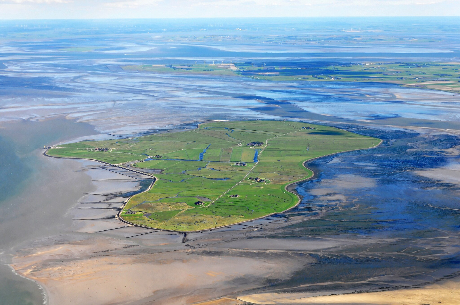
Hallig Hooge is characterized by large fallow areas, some of which are used for livestock farming. There are large areas of salt marsh on the east and west sides of the Hallig. While the North Sea is on the north side, large mudflats are exposed around the rest of the Hallig Hooge at low tide. Isolated hills with clusters of houses, small ponds and shrub structures allow very close observations of migrating songbirds, especially during migration periods.
On a small sandbank on the northeastern side of Hallig Hooge is a hightide roost of waders and other waterbirds. But during very high tides the entire island is used as a roost. Breeding birds include ústřičník velký, vodouš rudonohý and rybák malý on the small sandbar. Other birds you can encounter are depending on the season berneška tmavá, hvízdák eurasijský, husice liščí, kajka mořská, morčák prostřední, tenkozobec opačný, kulík bledý, kulík zlatý, koliha velká, břehouš rudý, kulík písečný, kamenáček pestrý, jespák obecný, bělořit šedý, linduška luční, rybák dlouhoocasý, rybák obecný and rybák severní. During migration time you can also encounter birds such as berneška rudokrká, sněhule severní, jespák mořský, budníček pruhohlavý, Konipas bílý ssp yarrellii, krutihlav obecný and all types of songbirds like trushes and flycatchers.
Details
Access
Hallig Hooge can be reached by ferry from Schlüttsiel (see link below). Press P on the map for directions to Schlüttsiel. The crossing from Schlüttsiel to Hallig Hooge takes approximately 1 hour and 15 minutes. Every point on the island of Hallig Hooge itself is easily accessible on foot or by bike. You can get around on foot on the Warften (small hills, including clusters of houses and bush structures), but there are also some private properties and private paths.
Terrain and Habitat
Wetland , Grassland , Scattered trees and bushes , Plain , Sea , Dunes , Pond , Mud flats , Agriculture , Reedbeds , City/villageConditions
Flat , Hilly , Open landscape , High water possibleCircular trail
YesIs a telescope useful?
Can be usefulGood birding season
All year roundBest time to visit
Spring migration , Autumn migrationRoute
Paved road , Wide path , Unpaved road , Narrow trailDifficulty walking trail
EasyAccessible by
Foot , Bicycle , WheelchairBirdwatching hide / platform
NoExtra info
berneška rudokrká polák kaholka turpan černý hohol severní husa běločelá polák kaholka potápka malá kukačka obecná lelek lesní rorýs obecný lyska černá jeřáb popelavý čejka chocholatá kulík říční kulík hnědý jespák křivozobý sluka lesní bekasina otavní lyskonoh úzkozobý pisík obecný vodouš kropenatý vodouš šedý chaluha příživná racek tříprstý rybák velkozobý potáplice malá terej bílý volavka stříbřitá kolpík bílý orlovec říční moták pilich rákosník zpěvný rákosník obecný budníček lesní budníček pruhohlavý budníček altajský budníček zlatohlavý Budnícek menší východoevropský šoupálek dlouhoprstý šoupálek krátkoprstý kos horský drozd brávník bělořit šedý konipas horský linduška skalní Konipas bílý ssp yarrellii Grey-headed Wagtail (thunbergi) Konipas luční ssp flavissima pěnkava jikavec konopka žlutozobá čečetka zimní strnad rákosní jestřáb lesní káně rousná káně lesní ledňáček říční krutihlav obecný dřemlík tundrový sokol stěhovavý ťuhýk obecný straka obecná kavka obecná havran polní vrána šedá skřivan ouškatý skřivan lesní sedmihlásek hajní rákosník proužkovaný


