

.jpg)
Description
The River Taw rises from a spring on Dartmoor to the South, after 45 miles it arrives at the large town of Barnstaple (formerly Barnstable). The Taw Estuary together with it's 'sister' estuary The Torridge (just to the West) is the only estuary complex on the North Devon coast. It holds the third largest concentration of birds in the county after the Exe and Tamar estuaries. Unlike those two the Taw is mostly sandy, but is one of those sites that has good birding at any time of the year.
The sides of the estuary are readily accessible due to old railway lines now converted into foot/cycle paths and there are numerous routes to take, the town of Barnstaple is directly connected to the main rail line (at Exeter) by way of a branch line.
Barnstaple Railway Station car park (fee payable) is a good place to start at the Eastern end of the estuary or alternatively at Velator Industrial Estate in the West (on road parking - limited spaces but free).
PRESS STARS ON MAP FOR NUMBERED INFORMATION OF THE FOLLOWING :
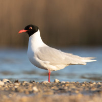
*1, TAW ESTUARY, SOUTH SHORE - Check estuary Gull (Laridae) flocks carefully for unusual species, from here the sun is behind you, avoiding low winter sun 'glare'.
*2, ROCK PARK - A town council run park beside the River Taw (still tidal here), Northern Wheatear, Goosander, Common Redshank, Common Greenshank and Passerines can be found here.
*3, BARNSTAPLE LONG BRIDGE to THE TAW BRIDGE - Check Gull (Laridae) flocks for species such as Ring-billed Gull and Mediterranean Gull, also Little Grebe, Eurasian Curlew, Grey Heron and Little Egret are also possible.
*4, TAW BRIDGE to BRADIFORD WATER - Still heading West along estuary edge foot/cyclepath, the estuary quickly widens. At low tide the mid estuary sandbanks can hold many birds. On the land side is Pottington Industrial Estate, a short detour gives views over Bradiford Water, a Devon Birdwatching and Preservation Society (DBWPS) Reserve (NOTE THIS IS A CLOSED RESERVE). Alternatively continue on estuary side footpath where there is still good views of Bradiford Water, the reserve has ponds and a scrape where Mallard, Northern Shoveler, Eurasian Teal, Eurasian Wigeon are usual, at high tide the reserve and surrounding fields are used as a high tide roost/feeding area by Northern Lapwing, Eurasian Curlew, European Golden Plover etc.
*5, BRADIFORD WATER to ROYAL MARINE BASE CHIVENOR - Still heading West look for Ashford Sewage Treatment Works on the Right, look through gates (NO ENTRY) for Pied Wagtail, White Wagtail and other Passerines roosting/feeding on and around filtration beds. On estuary sandbanks European Golden Plover are usually here, check flocks carefully for American Golden Plover and Pacific Golden Plover.
*6, RMB CHIVENOR - The path runs behind RMB Chivenor with no views of estuary.
*7, RMB CHIVENOR to VELATOR - After passing Airfield Crash Rescue Gate No 1 views open up to the South over Sherpa Marsh, where there is a scrape and often flooded fields that attract Black-tailed Godwit, Bar-tailed Godwit and numerous other birds that are easily viewable from the foot/cyclepath. This area also has DBWPS Velator Reserve (devonbirds.org) which operates as A CLOSED RESERVE ONLY. On the other side (North) of the path is Wrafton Pond (also called Velator Wetlands Project), an area of open fresh water surrounded by grass/trees/shrubs and reedbeds. There is a boardwalk from the foot/cyclepath out into the pond.
Details
Access
Leave Exeter on the A377 towards Crediton, continue on this road until you reach Barnstaple, follow signs to Town Centre and Railway Station.
Terrain and Habitat
Scattered trees and bushes , Grassland , River , Sea , Reedbeds , City/village , Agriculture , Beach , Lake , WetlandConditions
Flat , High water possible , Open landscape , SandyCircular trail
YesIs a telescope useful?
YesGood birding season
All year roundBest time to visit
Winter , Spring migration , Spring , Autumn , Autumn migrationRoute
Paved road , Wide path , Unpaved roadDifficulty walking trail
EasyAccessible by
Foot , Bicycle , Car , WheelchairBirdwatching hide / platform
NoExtra info
A TELESCOPE IS VITAL AT THIS SITE. Because of long distances involved you may decide to 'work the patch' from both ends and even miss out the *6, CHIVENOR section.
Other recommended nearby sites are - Fremington Quay and Pill; Home Farm Marsh; RSPB Isley Marsh, Yelland Quay and Instow; River Torridge - Instow Signal Box - Bideford - Beam Bridge; The Skern and Northam Burrows Country Park; Braunton Burrows - Braunton Marsh.


.jpg)

 ) to insert bird names in your own language. The birdnames will automatically be translated for other users!